
THE TRUCK, belching black diesel smoke, slithers and slides as it struggles up the steep incline of the wet road. It is not much of a road, although it used to be once, sure. Then the weather and the jungle got at it, patiently aiming to outlast it. Now this stretch is a collection of potholes stitched together with some tar, tiptoeing past dramatic gullies washed away by landslips.
From my window on the passenger side, I can look down the scar in the earth to a pile of debris far below, mixing red soil, greenery and tree trunks. Around me, the jungle stretches over peaks to the horizon, heavy with rain and threatening at any moment to take back the narrow strip of land it has lost to this alien invader. A grey sky mutes the colors, even of the toucans that flit through the branches with the ridiculous but wonderful beaks that threaten to unbalance them.
This is the kind of terrain through which the Panama Canal was carved, taking ten years and $350 million to complete, not to mention 26,000 lives lost to malaria and yellow fever before it opened in 1914. It helped California boom, brought decline to once-prosperous more southerly ports such as Valparaiso, and ended the romantic vision of ”Rounding the Horn” under sail. “The canal was the Apollo Moon Shot of its day,” says historian Carlos Herrera. “But it destroyed the reputation of French engineer Ferdinand de Lesseps, who found cutting one at sea level through the desert, as he did with Suez, was nothing like forcing one through Panama’s mountains and jungle.”
I met Carlos the day before, as I watched a top-heavy container ship make its way through the Miraflores Lock. The lock’s crowded restaurant serves a very popular buffet but everyone heads for the viewing platforms when a large vessel hoves into view. On deck, crewmen in fluorescent safety jackets seem as keen to take pictures of the spectators as we are to snap their ship. There are bare centimeters to spare as it is guided into the lock by the railway “mules” that aim to prevent any damage by runaway ship’s engines that might put the canal out of commission even temporarily.
“Five per cent of the world’s sea-borne trade passes through the canal every year,” says Carlos. “Panama brings in about $1 billion a year from tolls, charged at roughly $3.50 a tonne.” A loaded container ship pays from $50,000 to $250,000 for the 80km passage between the oceans, while the record is held by the cruise ship Norwegian Pearl, which paid $375,600.
I learn more such trivia in the entertaining museum at Miraflores, which tells the dramatic story of building the canal. It links the Pacific and Atlantic Oceans, cutting out the distance around Cape Horn on the tip of Latin America that adds more than 12,000km and some of the world’s worst weather to the voyage.
When de Lesseps’ attempt failed, the US government bought the assets at rock-bottom price and carried on, with President Teddy Roosevelt urging: “Make the dirt fly!” The figures are staggering: enough earth was excavated to encircle the world four times if it were loaded into a train of flat cars. “The real hero of the dig was Col. William C. Gorgas, who put in place measures to eradicate yellow fever and malaria,” says Carlos.
Roosevelt also helped create Panama itself, using US gunboats to ensure its split from Colombia so that the canal would have its own country under US control. “Of course, it was in the interest of the US to support Panama’s independence, but there was also a genuine homegrown movement for independence long before that. The Panamanian Revolution killed one person – and a donkey – so it had a lot of popular support.”
Panama has since grown from a Central American backwater into a prosperous modern state that took over full control of the canal on December 31, 1999 – “Our real independence day,” says Carlos – and and had now invested $5.25billion into widening it to take larger, and more, ships.
“The standard measure for ships is ‘Panamax’, which is defined as the widest the Panama Canal can handle,” says Carlos. “More modern ships – the so-called ‘post-Panamax’ vessels – were bypassing the canal, so it was decided to enlarge it. A national referendum was held to approve and won an almost 80 per cent vote, so it was a very popular decision at the time, back in 2006.
“It was a major construction project but the world recession has really hit since it was started, drastically cutting shipping, not to mention that Nicaragua has signed a deal with China to build an alternative. We even have to consider climate change opening up the Arctic for shipping. So the economics look very different now than when it was first planned.”
Engineer Ilya de Marotta, who has worked on the canal for decades, has no doubt about its potential. “The canal is an important source of revenue to the country and also of employment, with more than 10,000 people working on it,” she says. “I can understand why Nicaragua wants to emulate Panama’s success but the investment they will have to make is so huge that it is a very, very long term investment. From an engineering perspective, it is of course do-able. They have come to visit us to see what we’re doing, so they are serious about it. But I don’t know if it is financially feasible: that will depend on the Chinese.”
She does not see the Arctic Passage as an issue. “It is not open all year round and containerization needs a year-round route. Any ships will also need strengthened hulls as there is always the danger of icebergs. Suez has been and always will be a competitor, as is the rail bridge from east coast to west coast America. So we are not alone in the market, but I do not see any serious threats.”
Environmentalists, who point to the disruption to local wildlife, have also criticized the expansion. Panama lies on an important migration route for birds and you can see more bird species here than in the entire continental US and Canada combined. The canal may be a victim of its own success in this respect; an important part of its water management strategy is preserving forest reserves on both banks, as well as around Gatun Lake. The trees help stop silting up of the canal and the lake, which supplies hydropower as well as the 236million liters of water used for every passage through the lock system, not to mention drinking water to Panama’s cities. Key to the new locks is a set of water-saving basins that will help conserve 60 percent of the water used during each transit.
The thick rainforest around Gatun Lake remains almost untouched since long before the canal was built and is an important resource for studying Central American animal and plant species. The lake itself is growing in popularity for eco-tourism. At the luxury Gamboa Rainforest Resort, just 40 minutes away from Panama City, I take an open cable car above the lush canopy of the Soberania National Park. The ride is a birdwatcher’s dream, with yellow-billed toucans flying from treetop to treetop, among many other species. It ends at a tower with wonderful views of the Chagres River and the canal shimmering in the distance, a splash of light surrounded by greenery.
MY BIGGEST surprise in Panama has been this natural side. Although it shares a border, and many similarities, with Costa Rica, the country is nowhere near as well known as its neighbor for eco-tourism. My drive through its jungle has opened my eyes to its potential and I am on my way to somewhere even more remarkable. The road from El Llano to Cartí runs from the outskirts of Panama City to Guna Yala province, the semi-independent home of the indigenous Guna people on Panama’s Caribbean coastline. As my truck crests the Continental Divide, the Caribbean opens out below me through a gap in the brooding clouds and I can see the first of the San Blas Islands on the horizon.
These 380 islands, of which only 50 are inhabited, run along the north coast of Panama near its border with Colombia and form the major part of the semi-autonomous homeland of the Guna. Their desire to go their own way has seen them resist invaders since the Spanish Conquistadors onward and they have not been shy of chasing away – sometimes violently – any outside developers who signed dubious deals with the tribal council for hotels and other projects.
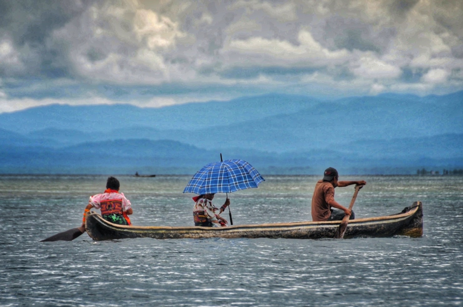
The result, as I discover when I take a battered wooden boat out to one, is a lifestyle that at first sight looks like a permanent holiday: fishing, lying in hammocks and drinking home-brew. That’s the men, obviously. The women have a tougher time of it, cooking, making the home-brew, looking after the children and making and selling the colorful mola cloths that are the main source of income.
The intricately sewn molas are based on body paint designs that were the Guna’s main decoration until European missionaries made them cover up. They are worn as headscarves or stitched into blouses and skirts, while the traditional costume is completed with long bands of beads wrapped tightly around arms and legs. Again, the men have it a bit easier, wearing faded shorts and T-shirts that seem better suited to the tropical climate.
My “hotel” turns out to be a ramshackle hut with a bare bulb as my room’s sole nod to the modern world, powered erratically by a solar panel. Its mosquito nets merely trap the insects inside once they have come in through the many holes. But that is part of the appeal of the San Blas: they are true desert islands. The next day dawns sunny and warm and I take a boat to explore further. I soon find myself on a literally deserted island of pure sand and a lone palm tree, with crystal clear water and a small coral reef offshore.
With no development, there is little risk of pollution or disturbance. Even jet skis and scuba diving, with its need for boats and compressors, are banned. The restriction on diving also gives species such as lobster a refuge at depth, a simple means of preserving them from over-fishing. I swim and snorkel for a while, then find a slightly bigger island where a small shack is selling freshly fried fish, lobster and plantains for lunch, with beer from a cool box.
The larger Isla Corbisky is home to around 200 Guna and offers a chance to see their daily life at first hand. “Children come here to school by canoe from the smaller islands,” says my guide, Gilberto, who has the typical short, stocky build of the Guna. “Fresh water also has to come from the mainland, where a lot of the men have small farms, although the land is passed down through the women. No one owns the land, which is held communally, but they have the right to use it and pass that right on. The same applies to the islands where coconuts are harvested, which was the main income before tourism. Be careful taking a coconut from any island – they all belong to somebody.”
Between fishing, farming and fetching water, the Guna men work a lot harder than it might at first appear. But, as a matriarchal society, the Guna’s most interesting ceremony is reserved for girls reaching puberty. This involves several days of celebration, with her parents supplying free food and booze for the whole community. There are a lot of children running around the island, so it is no surprise to find one such ceremony taking place. The men are lying quietly on hammocks in a smoky, dark communal hut, while a few women are cooking yams in a pot, all giving the impression of suffering from a bad hangover. The only signs of life in the entire settlement are the kids at play and some older women stitching, and hoping to sell, molas in the traditional colors of black, red, burgundy and a splash of orange.
Besides her traditional dress, every Guna woman has a gold ring through her septum. “The first ceremony for every baby girl is the ikko inna or needle ceremony, when her nose is pierced,” says Gilberto. “Then there are two puberty rites: the inna tunsikkalet (short ceremony) and the inna suit (long ceremony), where her hair is cut for the first time. Afterwards, she must wear the molas and a head scarf and is ready for marriage.” Guna boys have no similar rites.
Gilberto was born here but now lives in Panama City and I catch him giving a wistful look out of the plane window as we fly off from the small airfield on Porvenir a few days later. “Life here is much better,” he says. “No stress, no noise and you are close to nature. But I want to give my children an education and, once you have left, it is very hard to go back.”
There are many Guna to be seen on the streets of Panama City, with a mini-industry of shops catering to them and tourists, selling molas and the cloth to make them. “Many came to work for the Americans in the Canal Zone,” says Gilberto. “Now they mostly make a living from tourism. You can see the molas changing to reflect the demand for things like iPad covers. Young people are also learning English as well as Spanish and the danger is that the Guna language and culture will die.”

The city is booming with visitors and a walk around is an obstacle course of road works and scaffolding around building sites. A lot quieter, but still being transformed, is the oceanfront Casco Viejo. The old city was a crumbling, deserted pile of ruined colonial houses at the end of the 20th century, but developers have now moved in with art galleries, restaurants, bars and boutique hotels lurking discreetly behind brightly painted shutters. I take a stroll, enjoying a slice of fresh green mango sprinkled with salt sold by a smiling old lady sitting under a shady tree on Plaza Bolivar. In the evening, the plaza comes alive with al fresco music and a lively bar. The city walls, built by the Spanish in 1673, to defend it from pirates such as the notorious Henry Morgan seem more likely to keep visitors inside what is now a Unesco World Heritage Site.
The previous city, Panama Viejo, was built in 1519 and burnt by Morgan in 1671. All that remains is a pile of atmospheric ruins with a scenic outlook over the skyscrapers of Punta Pacifico. “Panama Viejo was the first city built on the Pacific Coast of the Americas,” says Carlos. “Morgan targeted it because it was the port to which the Spanish shipped all the riches stolen from the Incan Empire. The gold was then taken by mule across the Isthmus to the Atlantic coast for shipment back to Spain.”
One legacy of all that gold is the altar of St Joseph’s church, Inglesia de San Jose. Made of wood covered in gold plundered during the Spanish conquest, this magnificent altar was whitewashed by the Jesuits to disguise it from Henry Morgan in 1671. Legend has it the priest’s protestations of poverty actually led to the notorious pirate giving him a donation.
Another legacy of old Panama is the fish market. The Mercado de Mariscos is a busy hall where fishermen sell directly to vendors, a guarantee the produce is as fresh as you can find short of catching it yourself. Upstairs, a restaurant cooks every variety of seafood to order and also specializes in ceviche, the marinated raw fish that is a popular local snack.
Spinning a coin on the table while I wait for my order, I note that both Panama’s beer and its currency are named after Balboa, the first European to cross the Isthmus and see the Pacific in 1513. Vasco Núñez de Balboa’s helmeted profile is a constant reminder of how this narrow strip of land has been key to uniting the world’s two great oceans.
For my own exploration of the Pacific, I take a drive along the Amador Causeway that runs south to join four islands that each bring their own touch of green to the city. The six-kilometer causeway was built using rock excavated during the Canal’s construction and my drive is rewarded by lovely views back into the Panama City. As dusk grows, the lights of skyscrapers and office blocks burn like a manifestation of Panama’s ambitions. Offshore, lines of ships from all over the world sit patiently at anchor, waiting their turn to enter the Canal and continue their voyages to the Atlantic and beyond.

You must be logged in to post a comment.